When we think of satellites in space, we often imagine them simply “floating” above Earth. In reality, they are in constant motion, traveling along carefully planned paths called orbits. These orbits determine what satellites can do, what they can see, and how they connect with Earth.
On this page, you’ll learn what orbits are, why they matter, and how different types of orbits serve different purposes.
What is an orbit?
- Example:
- Imagine throwing a ball forward. On Earth, it eventually falls to the ground because of air resistance and gravity.
- Now imagine you’re in space, where there’s no air to slow the ball down. If you throw it fast enough, gravity will still pull it down – but the Earth curves away beneath it at the same time.
- The result? The ball keeps “falling” around the Earth, never hitting the ground.
- That’s what an orbit is: a state of constant free-fall around a planet, thanks to the balance between speed and gravity.
- The choice of orbit depends on the mission: observing Earth’s surface, enabling global navigation, providing internet, or monitoring weather.
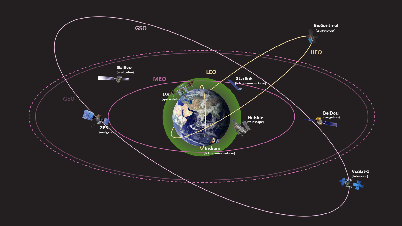
Main Types of Orbits
Low Earth Orbit (LEO)
- The altitude is <1,600 km (as low as 160 km). Orbital plane is usually tilted relative to equator.
- The orbit of the ISS (International Space Station) (400 km) and Hubble Space Telescope (540 km).
- To stay in orbit at such altitude range:
- Speed required: 7.8 km/sec
- One orbit: 90 mins
- Used for satellite imaging, remote sensing, telecommunication.
- Multiple satellites are deployed as a network of linked satellites / ’constellation’ to cover large areas of Earth (E.g. Starlink, Iridium).
- Undergo orbit decay and require course correction due to dense atmosphere. Lifespan is about 7-10 years.
Medium Earth Orbit (MEO)
- The altitude is between 2,000 km to 35,786 km. a.k.a mid Earth orbit or intermediate circular orbit (ICO).
- Used especially by navigation and positioning satellites:
| GLONASS (RUS) | 19,100 km | Orbit: 11 hrs 16 mins |
| GPS (US) | 20,180 km | Orbit: 11 hrs 58 mins |
| BeiDou (China) | 21,528 km | Orbit: 12 hrs 53 mins |
| Galileo (EU) | 23,222 km | Orbit: 14 hrs 4 mins |
- Semi-Synchronous orbit falls under MEO Orbit:
- At an altitude of approx. 20,200 km the satellite has an orbital period of 12 hrs. i.e, in 24-hours, the satellite crosses over the same two spots on the equator every day.
- Considered consistent and highly predictable.
- Molniya Orbit:
- Designed by Russia, the satellite spends 2/3 of its time over one hemisphere. Useful for communications and observations at higher latitudes.
- Orbital period is 12 hrs.
Geosynchronous Orbit (GSO)
- It’s orbital period matches the Earth’s rotation on its axis.
- One orbit takes 23 Hrs 56 mins and 4 secs (the same time Earth takes to complete one rotation).
- It is ’fixed’ above a particular location above the Earth’s surface.
- The orbit is also called Clarke Orbit – named after Arthur C. Clarke. The collection of satellites in this orbit is called Clarke Belt.
- Tundra Orbit:
- An eccentric geosynchronous orbit with an inclination of 63.4o.
- The satellite spends most of the time over one high latitude location.
- At least two satellites are required to provide continuous coverage over an area.
- Quasi-zenith Orbit:
- Quasi-zenith satellite system (QZSS) – a 4-satellite system with an inclination of 42o and 0.075 eccentricity.
Geostationary Orbit (GEO)
- A special case of GSO, it’s a circular geosynchronous orbit in Earth’s equatorial plane with both inclination and eccentricity equal to 0. a.k.a Geosynchronous Earth orbit (GEO).
- Circle above the equator in a west to east direction.
- To match Earth’s rotation:
- Speed required: 3 km/sec
- Altitude: 35,786 km
- Due to high altitude, a single satellite can cover a large area of Earth (three satellites could cover the entire planet).
- Mainly used by telecommunication and weather satellites.
Geostationary Transfer Orbit (GTO)
- A highly elliptic, Geocentric Orbit.
- Satellites to be put for GSO or GEO are put into this orbit as an intermediate orbit.
- It has a perigee in LEO and an apogee at the GEO altitude of 35,786 km.
- It requires less fuel to place a satellite in GTO compared to directly placing it in GSO or GEO.
- The satellite performs series of maneuvers to circularize its orbit and reach GEO.
- Communication, weather and military satellites are placed in this orbit before they reach their final position in GEO.
Polar Orbit
- A orbit that passes over the Earth’s poles.
- Over time, the satellite covers every part of the Earth’s surface.
- It’s not necessary to precisely pass over the south and north pole. A deviation within 20o to 30o is still classified as a polar orbit.
- It is a type of LEO with altitudes ranging between 200 – 1000 km.
Sun-Synchronous Orbit (SSO)
- A sub-sect of polar orbit (a.k.a Heliosynchronous orbit).
- The satellite always visits the same spot at the same local time. Hence it is synchronous with the sun, i.e, has the same fixed position relative to the sun.
- Useful in applications where an area needs to be monitored as to how it changes over a period of time.
High Elliptical Orbit (HEO)
- An elliptic orbit with high eccentricity, with one center around the Earth.
- Satellites appear to move slowly and stay for longer duration at a point in the sky as they approach and descend from apogee.
- Satellites typically cover high-latitude ground sites. Useful for communication satellites.
- GEO orbits cannot cover ground in high latitudes as their elevation above the horizon in these ground regions is very low. (Latitude limit for a GEO satellite is 81o)
- Molniya orbits and Tundra orbits are examples of HEO.
Heliocentric Orbit (HCO)
- An orbit centered around the Sun (technically the barycenter of the Solar System).
- Barycenter is the center of mass of two or more bodies orbiting one another.
- Asteroids and comets follow heliocentric orbits.
- Space probes (Voyager 1 and 2), Mars rovers (Perseverance), Asteroid probes (OSIRIS-Rex) travel to their destinations by first being placed in heliocentric orbits.
- Sun observing satellites for monitoring solar activity are placed in heliocentric orbits.
Lagrange Points (L-points)
- These are specific points far out in space where the gravitational fields of two celestial objects is precisely equal to the centripetal force required for a small object to move with them.
- L-points allow for orbits that are much farther away and do not orbit the Earth directly. They reduce fuel consumption needed to remain in position.
- L-points L1 and L2 are most used (1.5 million km from Earth).
- Used for space observing missions where being too close to Earth or the Sun is deterimental and prevents the satellites from detecting faint sources like distant galaxies. (JWST, GAIA at L2 point, SOHO at L1 point)
- L-Points exist between any 2 celestial objects. L-Points between Earth and Sun are different than L-Points between Earth and the Moon.
- Named after 18th century Italian astronomer and mathematician Joseph-Louis Lagrange.